UPDATED FORECAST – MAY 2026
The 2026 Atlantic Hurricane Season: El Niño Reshapes the Outlook
A consolidated look at the five major forecasts, the looming “Super El Niño,” and what it means for coastal residents, insurers, and FEMA’s flood program.
SEASON AT A GLANCE
- Season runs June 1 – November 30, 2026. Consensus outlook: BELOW-NORMAL a sharp reversal from 2024 and 2025.
- Primary driver: a developing El Niño – with a roughly 50% chance of reaching “Super El Niño” intensity (+2.0°C anomaly) by late season.
- NOAA forecast range: 8-14 named storms, 3-6 hurricanes, 1-3 major hurricanes. The 30-year average is 14/7/3.
WHAT’S CHANGED SINCE OUR LAST UPDATE
- NOAA released its official outlook on May 21, 2026 – below-normal with 8-14 named storms.
- CSU’s April 9, 2026 forecast came in below normal – 13/6/2 – the lowest CSU has called since 2019.
- TSR slashed its December projection by roughly 40% in its April update.
- Odds of a Super El Niño have roughly doubled since April now approaching 50%.
A Brief History of Hurricane Forecasting
Hurricane forecasting has come a long way in just over a century. When the Great Galveston Hurricane struck Texas in September 1900, the U.S. Weather Bureau had no satellites, no radar, no aircraft, and no computer models. The catastrophic loss of life between 6,000 and 8,000 people in a single night was the spark that eventually transformed weather forecasting into a national priority. By the mid-1940s, military pilots were flying into storms to measure them firsthand; by 1960, the TIROS-1 satellite gave humans their first view of a hurricane from space.
Seasonal forecasting – the kind of forecast this report focuses on – began in 1984, when the late Dr. William Gray of Colorado State University issued the first peer-reviewed prediction of how many named storms an Atlantic season would produce. NOAA followed with its official seasonal outlook in 1995, and a small ecosystem of forecasters – AccuWeather, Tropical Storm Risk in the UK, and the UK Met Office – now publishes complementary outlooks each year.
| Era | Milestone in Hurricane Forecasting |
| 1900 | The Galveston Hurricane kills 6,000-8,000 the deadliest natural disaster in U.S. history. There is no organized forecasting system. |
| 1944 | First aircraft reconnaissance – the “Hurricane Hunters” begin flying into storms. |
| 1960 | TIROS-1, the first weather satellite, transforms tropical-cyclone detection. |
| 1984 | Dr. William Gray (Colorado State University) issues the first seasonal Atlantic hurricane forecast. |
| 1995 | NOAA launches its official seasonal outlook through the Climate Prediction Center. |
| 2023 | NOAA debuts the Hurricane Analysis and Forecast System (HAFS) a next-generation coupled ocean-atmosphere model. |
| 2024-26 | AI-based forecasting (Google’s GraphCast, NVIDIA FourCastNet) rivals traditional models for track prediction; NOAA introduces an experimental forecast cone reflecting uncertainty in both direction and timing. |
How Forecasting Has Changed and Where It Still Struggles
The most dramatic improvements have come in track forecasting. A modern 72-hour hurricane track forecast is now as accurate as a 24-hour forecast was in 1990 an improvement of roughly two-thirds. Intensity forecasting, however, remains the field’s great unsolved problem. Rapid intensification a jump of 35 mph or more in 24 hours still catches forecasters off guard, as it did with Hurricane Otis in 2023 and Hurricane Melissa in 2025.
NOAA’s Hurricane Analysis and Forecast System (HAFS), which became operational in 2023, has cut intensity-forecast errors by an estimated 10-15% in its first two seasons. Machine-learning models from Google, NVIDIA, and academic labs now match or beat the European model on track at certain lead times at a fraction of the computing cost. For 2026, NOAA is also rolling out an experimental track-forecast cone that conveys uncertainty in both the direction and the timing of a storm, rather than direction alone.
The 2026 Forecasts – Updated
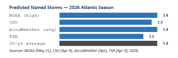
Five major institutions issue seasonal forecasts for the Atlantic basin. Compared with the early-April snapshot, the picture has consolidated significantly: every issued forecast now points to a below-normal season, and the magnitude of the suppression has grown.
| Source | Issued | Named Storms | Hurricanes | Major Hurricanes | vs. Avg. |
| NOAA (NEW) | May 21, 2026 | 8-14 | 3-6 | 1-3 | Below |
| CSU | Apr 9, 2026 | 13 | 6 | 2 | Below |
| AccuWeather | Apr 2026 | 11-16 | 4-7 | 2-4 | Near-Below |
| TSR (UK) | Apr 9, 2026 | 12 | 5 | 1 | ~40% |
| UK Met Office | Pending* | Below | |||
| 1991-2020 Average | Climatology | 14 | 7 | 3 |
* The UK Met Office’s May 2026 outlook had not yet been published at the time of this update; the agency typically issues its forecast in late May.
Report #1 – NOAA Climate Prediction Center (NEW: May 21, 2026)
NOAA released its official 2026 Atlantic outlook on May 21, 2026, in a news conference at the agency’s Aircraft Operations Center in Lakeland, Florida. The forecast calls for 8 to 14 named storms, 3 to 6 hurricanes, and 1 to 3 major hurricanes, with a 55% probability of a below-normal season, 35% near-normal, and only 10% above-normal. NOAA cites the developing El Niño as the primary suppressing factor, noting that warmer-than-average Atlantic sea-surface temperatures and slightly weaker trade winds are providing a partial counterweight. This is NOAA’s first below-normal Atlantic outlook since 2015.
Report #2 – Colorado State University (April 9, 2026)
CSU’s TC-RAMS team the group that inherited Dr. William Gray’s seasonal program issued its first 2026 forecast on April 9. Lead author Phil Klotzbach called for 13 named storms, 6 hurricanes, and 2 major hurricanes, citing a “high likelihood of robust El Niño and associated increases in vertical wind shear” as the primary driver. The team predicted that 2026 tropical Atlantic vertical wind shear will be the second-highest since 1981 trailing only the 2015 super-El-Niño season. CSU’s next update is scheduled for June 10, 2026.
Report #3 – AccuWeather (April 2026)
AccuWeather Lead Hurricane Expert Alex DaSilva projected 11 to 16 named storms, 4 to 7 hurricanes, and 2 to 4 major hurricanes – with 3 to 5 storms expected to directly impact the United States. The firm explicitly flags the northern and northeastern Gulf Coast and the Carolinas as the highest-risk landfall regions for 2026, based on analog years such as 2009, 2014, 2018, and 2023. AccuWeather warns that even in a quieter year, one significant landfall can define the season.
Report #4 – Tropical Storm Risk (April 9, 2026 Update)
The most aggressive downgrade came from Tropical Storm Risk (TSR), the London-based consortium of University College London researchers. In December 2025, TSR had forecast a near-normal 14 named storms, 7 hurricanes, and 3 major hurricanes. Their April update slashed those numbers to 12/5/1, with the Accumulated Cyclone Energy (ACE) index nearly halved – from 125 down to 66. TSR now projects an Atlantic season roughly 40% below the 1991-2020 climatology, citing “moderate or strong El Niño conditions through summer and autumn 2026.” Their forecast for U.S. landfalls is just 1 hurricane and 3 tropical storms.
Report #5 – UK Met Office (May 2026, Pending)
The UK Met Office uses its GloSea6 dynamical model to issue an annual May outlook. As of this update, the 2026 forecast had not yet been released; the agency typically publishes in late May. Based on preliminary GloSea ensemble runs reportedly informing the CSU and TSR forecasts (both of which incorporate UKMET model output), the Met Office is widely expected to project a below-normal season we will update this report when the official numbers are released.
The Wild Card: A Possible Super El Niño
WHAT IS A “SUPER EL NIÑO”?
An El Niño is classified as “Super” when sea-surface temperature anomalies in the equatorial Pacific’s Niño 3.4 region exceed +2.0°C above average. Only a handful of such events have been recorded in the modern era 1982-83, 1997-98, and 2015-16 and each upended weather across the globe.
As of mid-May 2026, ECMWF and IRI model guidance now show a roughly 50% probability that the developing El Niño reaches Super status by autumn with some ensemble members projecting Niño 3.4 anomalies near +3.0°C which would rival or exceed the 1877-78 record.
The single biggest variable for the 2026 Atlantic season is no longer whether El Niño will form – it almost certainly will – but how strong it gets. The transition from the weak La Niña that closed out the 2025 season to ENSO-neutral conditions is now complete. Subsurface ocean temperatures in the equatorial Pacific are rising rapidly, and most major modeling centers ECMWF, NOAA’s CFSv2, and the IRI multi-model ensemble now project a moderate-to-strong El Niño by the peak of hurricane season in late August through October.
What has changed since April is the upper tail of those projections. In February, the IRI ensemble peaked around a +0.7°C Niño 3.4 anomaly a weak event. The current forecast peaks near +1.5°C, with individual ensemble members reaching +3.0°C, which would tie or break the 1877-78 historical record. The probability of a Super El Niño defined as an SST anomaly of +2.0°C or greater has roughly doubled since early April, from about 25% to near 50% as of mid-May.
Why this matters for hurricanes: El Niño suppresses Atlantic activity by re-routing the subtropical jet stream, which dramatically increases vertical wind shear over the tropical Atlantic and Caribbean. A hurricane is effectively a vertical chimney of warm, rising air; strong shear blows the top of that chimney sideways, preventing the storm from organizing. The stronger the El Niño, the stronger the shear, and the harder it is for major hurricanes to form. During the 2015-16 Super El Niño, only 11 named storms formed in the Atlantic; the 1997-98 event produced just 8.
But Atlantic hurricane seasons do not bow to El Niño automatically. Two recent counterexamples are worth remembering. In 2004, an El Niño season, four major hurricanes Charley, Frances, Ivan, and Jeanne struck Florida within six weeks. In 2023, record-warm Atlantic sea-surface temperatures overwhelmed the suppressing shear and the basin produced 19 named storms. The same dynamic is in play for 2026: Atlantic SSTs remain warmer than normal, particularly in the western Gulf and Caribbean. CSU and AccuWeather have both flagged this as a setup for fewer storms but potentially intense ones that develop close to the U.S. coastline rather than from the African wave train.
| Region / Sector | Potential Super El Niño Impact (2026) |
| Atlantic basin | Aggressively suppressed activity. CSU projects 2026 wind shear will be the second-highest since 1981, behind only 2015. Late-season activity (Oct-Nov) likely to fall off sharply. |
| Eastern & Central Pacific | NOAA forecasts a 70% chance of an above-normal Pacific season 15-22 named storms, 9-14 hurricanes, 5-9 majors. Elevated risk for Hawaii, Mexico, Southern California. |
| U.S. Southern Tier | Wetter, stormier autumn/winter expected from California through the Gulf Coast to Florida elevated flood, severe-weather, and tornado risk well outside hurricane season. |
| Global temperature | Super El Niño events historically push global average temperature 0.1-0.2°C higher in the following calendar year. 2027 could set a new record. |
| Insurance & reinsurance | Lower expected Atlantic loss – but historical exceptions (2004, 2023) warn that warm Atlantic SSTs can override El Niño shear. NFIP claim exposure remains elevated. |
FEMA, the NFIP, and What a Quieter Year Means for Coastal Homeowners
FEMA the Federal Emergency Management Agency is the federal government’s lead agency for disaster response and recovery. Within FEMA, the National Flood Insurance Program (NFIP) is the only program in the country that underwrites residential flood insurance at scale. As of 2026, the NFIP holds approximately 4.7 million policies in force, covering more than $1.3 trillion in exposed property value. Private flood insurers exist, but their combined book remains less than 10% of the federal program.
The NFIP is financially stressed. The program borrowed heavily from the U.S. Treasury after Hurricanes Katrina (2005), Sandy (2012), and the Harvey/Irma/Maria trio (2017), reaching a peak debt of $24.6 billion before Congress forgave $16 billion in 2017. The program has been operating on short-term reauthorizations ever since more than 30 of them and currently sits at roughly $22.5 billion in Treasury debt against a $30.4 billion borrowing cap. The next reauthorization deadline is September 30, 2026.
| Year | NFIP Debt to Treasury | Context |
| 2005 | $17.5B | Post-Katrina borrowing. |
| 2017 | $20.5B | Congress forgives $16B after Harvey/Irma/Maria. |
| 2024 | $20.5B | Borrowing authority capped at $30.4B. |
| 2026 | ~$22.5B | Program faces September 30 reauthorization deadline. |
CONSUMER NOTE
Standard homeowners insurance does NOT cover flood damage. Federal flood policies have a 30-day waiting period, so the time to act is well before any storm forms. A below-normal forecast is not a guarantee of safety a single storm at the wrong location can rewrite the season.
For homeowners, a below-normal forecast can be deceptive. The 1992 season produced only seven named storms one of which was Hurricane Andrew, a Category 5 strike on South Florida that caused $27 billion in 1992 dollars of damage and effectively rewrote U.S. building codes. The 2004 Florida quartet happened in an El Niño year. The takeaway: seasonal totals do not predict where storms go, and a single landfall can define a year.
Bottom Line for 2026
Every major forecast issued for the 2026 Atlantic hurricane season points in the same direction: a quieter year than 2024 or 2025, with named-storm totals likely between 12 and 14, hurricane totals between 5 and 7, and major hurricanes between 1 and 3. The developing El Niño potentially reaching Super status by autumn will be the dominant climate driver, generating the kind of high-altitude wind shear that has historically torn apart developing Atlantic storms.
But forecasts describe the basin, not your neighborhood. Warm Atlantic and Gulf waters mean that any storm which does form has the fuel to intensify quickly and homegrown systems close to the U.S. coastline are a particular concern this season. AccuWeather has flagged the northern and northeastern Gulf Coast and the Carolinas as elevated-risk landfall zones, and NOAA explicitly cautions that “it only takes one storm to make for a very bad season.”
Coastal residents, business owners, and policy planners should treat the 2026 season exactly as they would any other: review evacuation plans, build a kit, secure flood insurance during the existing waiting period, and stay current with both the National Hurricane Center (hurricanes.gov) and local emergency management. The numbers may be lower this year. The stakes are not.
Sources & Citations
- NOAA, “NOAA predicts below-normal 2026 Atlantic hurricane season,” press release, May 21, 2026. noaa.gov
- Klotzbach, P. et al., “Extended Range Forecast of Atlantic Seasonal Hurricane Activity for 2026,” Colorado State University Tropical Cyclones, Radar, Atmospheric Modeling and Software Team (TC-RAMS), April 9, 2026. tropical.colostate.edu
- AccuWeather, “Atlantic hurricane season forecast 2026: 11-16 named storms predicted,” Brian Lada, April 2026. accuweather.com
- Tropical Storm Risk (TSR), “April Forecast Update for North Atlantic Hurricane Activity in 2026,” April 9, 2026.
- UK Met Office, “North Atlantic Tropical Storm Seasonal Forecast,” May 2026 update (pending at publication). metoffice.gov.uk
- FOX Weather, “NOAA reveals 2026 Atlantic hurricane season activity forecast as Super El Niño looms,” May 21, 2026.
- The Weather Channel / weather.com, “A Super El Niño Is Possible Later This Year – What That Could Mean for Hurricane Season and Winter,” 2026.
- FEMA, “Flood Insurance – National Flood Insurance Program (NFIP),” fema.gov, accessed May 2026.
- Congressional Research Service, “Introduction to the National Flood Insurance Program (NFIP),” Report R44593, updated 2025-2026.
- U.S. Government Accountability Office, “Flood Insurance: Comprehensive Reform Could Improve NFIP’s Financial Solvency”, various reports, 2017-2025.
DISCLAIMER: Forecast figures reflect the most recent published outlooks as of May 22, 2026. NOAA and CSU will issue updates throughout the season; the UK Met Office’s 2026 outlook was pending at the time of publication. All NFIP financial figures are drawn from FEMA, the Congressional Research Service, and the U.S. Government Accountability Office. This document is for informational purposes only and does not constitute insurance or financial advice. Always consult FEMA, your insurer, or local emergency management for preparedness guidance.